Saturday, September 28, 2013

Making progress

Yesterday morning we recovered a Mixed Layer Float (MLF; from U. Washington) that had been drifting about the SPURS area for the past 6 months.  Amazingly, it drifted right into the center of the moored array just as Endeavor reached the area.  Jason Smith and Dave Rivera used the small boat the grab the MLF, tow it close to Endeavor, and attach it to the crane for recovery.


Our colleagues at NOAA/PMEL in Seattle contributed two moorings to the SPURS moored array.  Both have a surface buoy with meteorological instruments, and a wave-powered "prawler" which collects underwater profiles of temperature and salinity. 

The PICO-East mooring lost its surface buoy several weeks ago.  Yesterday, after a good deal of searching and head-scratching, we recovered the remaining underwater portion of this mooring including the prawler.  Each moorings consists of several miles of rope and wire -- in the case of the damaged PICO-East much of the rope and wire was recovered in the form of giant wuzzles.  We wound everything, wuzzles and all, onto the winch last night then cleared it off by hand this morning.


We recovered the entire PICO-North mooring today.  No searching.  No head-scratching.  No wuzzles.  


Over the next few days we expect to recover 3 Wave Gliders and the gigantic WHOI flux mooring.

Thursday, September 26, 2013

SG122 recovered

Three Seagliders operated by SPURS colleagues at the University of Washington have been patrolling the upper 1000 m of the SPURS domain for the past 6 months. This morning we recovered Seaglider 122.  She appeared to be in good shape with just a few barnacles on the wings and a little slime on the hull.  


We are going to take advantage of the excellent weather and try to recover as much gear as possible over the next few days.  We're now heading towards the big WHOI flux mooring to do a visual inspection of the surface buoy.  Then we'll communicate acoustically with the remaining bits of the parted PICO-E mooring and try to make acoustic contact with the mute Seaglider 160.  Tomorrow morning we'll grab the UW/APL Mixed Layer Float (MLF) and recover the PICO-E mooring. 

Surface salinity just south of the moored array is near 37.65 -- the highest we've seen so far, but a bit lower than last fall.  Model guidance from JPL suggests that slightly higher salinity water lies just a bit to the west of us.  We'll explore as time permits.

Dave Rivera took this great picture of Endeavor during the SG recovery this morning.  Note the salinity snake on the starboard side beneath the bridge. 


Wednesday, September 25, 2013

Beneath the surface

Guest Blogger:  Dr. Ben Hodges (WHOI)

Just as oil floats on top of vinegar, lighter water floats on top of heavier water in the ocean. What determines the heaviness of seawater? Two properties: temperature and salinity. As water gets colder or saltier, it gets heavier.


In the deep ocean, isolated from the warming of the sun’s rays and the stirring caused by the wind, these two properties (temperature and salinity) don’t change very quickly. At the surface though, they do change. When it’s exposed to cold air, seawater can cool; when exposed to dry air, it can get saltier as the evaporating fresh water leaves its salt behind. Seawater can also get saltier as ice forms: the ice contains less salt than the liquid water that froze to make it, leaving excess salt in the surrounding (still liquid) water. These three processes can make seawater at the surface get heavier. If it gets heavy enough, it sinks into the quiet depths of the ocean.


Every bit of water in the deep ocean is on a journey that began at the surface some time in the past, and will end at the surface again some time in the future. Interestingly, most of these journeys begin in a few relatively small areas of the ocean surface, and each such location has its own unique combination of temperature and salinity. Just by measuring these two properties far below the surface, scientists can trace the journey of seawater back to where it began, often decades ago and thousands of miles away. 


As we head northward along the 38° W meridian, we stop every 60 nautical miles to lower an instrument package more than a mile into the sea and haul it back up again. Besides measuring temperature and salinity (and dissolved oxygen), the package has an array of bottles to bring seawater from various depths back onboard. Jason Smith (above) uses a sensitive instrument called a salinometer to double-check the salinity of the water from each bottle, so any error or drift in the lowered electronic sensors can be accounted for.

Far below us, as we float here in the middle of the Atlantic Ocean, there’s “North Atlantic Deep Water” that left the surface near Greenland long ago; we capture some of it in bottle, 1500 meters deep.  A little above that, there’s slightly fresher water that was last at the surface somewhere between Cape Horn (the southern tip of South America) and Antarctica; the bottle from 1000 meters brings some of that up. In less than two hours, we can collect samples of water that began their undersea journeys on opposite sides of the globe. The graph below shows the salinity profiles from our first four casts along 38° W, with water masses labeled.  


Tuesday, September 24, 2013

Buoy ride

This morning we reached the southernmost extent of our voyage -- a mooring at 20N, 38W that is part of the international PIRATA array spanning the equatorial Atlantic.  Although winds and seas are up a bit from yesterday (15-20 kts, 6-8 ft waves with swell from the NE), Dave Rivera (PMEL) and Jeff Lord (WHOI) took a ride in Endeavor's small boat to replace a faulty temperature and humidity sensor that is part of the mooring's meteorological instrument package.  Dave had the pleasure of climbing up onto the buoy to swap out the sensor -- not an easy thing to do on a slippery and round buoy hull.

The entire operation went very smoothly thanks to the careful work of Endeavor's bosun, Patrick Quigley, and his deck crew.  We have lots more small boat work ahead so its good to know we can operate even when conditions aren't perfect.

From here we trek north along 38W towards the SPURS moored array with stops for a few CTD casts and a seaglider recovery on the way.


Saturday, September 21, 2013

Solid backup


The weather continues to improve as we steam south and away from the remnants of Humberto.  Today was mostly sunny with just a few scattered showers and 10-12 kt winds.  Very pleasant.  The water is crystal clear, about 25 C (77 F), and we're definitely heading into the Atlantic salinity maximum -- surface salinities rose from 36.7 to 37.4 over the past 24 hours / 250 nm.


After supper this evening we completed our first 2000 m CTD cast at 30 deg N.  Two shallower test casts last night uncovered a damaged electrical connection on a Sea-Bird pump that resulted in noisy, contaminated data.  Endeavor's everywhere-all-the-time survey tech, Lynne Butler (above) figured this out quickly and swapped in a new pump and cable.


We had a bit of a scare during the same cast last night when the conducting wire jumped a sheave on the main traction winch -- bringing the upcast to a grinding halt. On went the chinese fingers to hold the weight of the instrument package while the engineers made repairs.  For today's cast we switched over to the #2 hydrographic winch and everything worked smoothly.  Our tiny science party (5 people) is fortunate that the capable crew of Endeavor is always there to help.

Unlike many physical oceanographic cruises, ship-based CTD profiling of temperature and salinity is not a central element of the SPURS fieldwork.  Rather, for the past 12 months, the SPURS program has employed a persistent autonomous observing system consisting of drifters, floats, gliders, Wave Gliders, and moorings.  You can see the present status of all of these platforms on the SPURS project website:  http://spurs.jpl.nasa.gov/SPURS/

Friday, September 20, 2013

Snakes on a ship

Guest Blogger:  Dr. Ben Hodges (WHOI)


As the Endeavor steams along, seawater is drawn in continuously and analyzed with onboard sensors.  We left Ponta Delgada yesterday morning, heading south-southwest toward a mooring that needs a repair.  When we arrive there in a few days, we’ll have a record of changes in salinity, temperature, and chlorophyll concentration every second along a line over a thousand miles long.  This line is about 5 meters below the surface of the ocean, since the seawater intake in the bottom of the hull is about that deep.

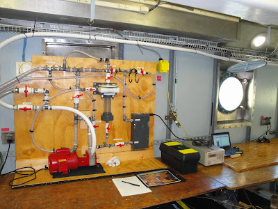
Wind tends to stir up the upper layer of the ocean, keeping it homogenous, so the water 5 meters deep and right at the surface are usually pretty much the same.  On very calm days though, there are sometimes big changes near the surface, even in the top meter.   Right after it rains, there might be a “puddle” of fresher water sitting on top of the saltier water below; or, on a hot sunny day, evaporation from the surface might make it saltier than the deeper water. We’re using a “snake” to suck up water from just beneath the surface, so we can keep track of these changes in salinity as we steam along.  The snake is a hose that drags along from the end of a long boom, which keeps it away from the side of the ship—too close, and it might take in deeper water churned up by the Endeavor.


Seawater enters the snake from a few inches beneath the surface through small holes in the bottom of the hose.  Inside the ship, a pump moves the water through a system that removes air bubbles, and then measures the amount of dissolved salt it contains.  


Wednesday, September 18, 2013

Ready to sail

R/V Endeavor is ready to depart tomorrow morning from Ponta Delgada, Azores, for the third and final SPURS cruise in the tropical Atlantic.  The crew and science party have worked hard over the past several days to prepare the ship and the instrumentation for the work ahead.  We've also had time to enjoy beautiful scenery, friendly people, and excellent food.


The primary objective of this cruise is the final recovery of the various moorings and robots that have been measuring the Atlantic salinity maximum region for the past 12 months.  Following departure we will head southwest.   The first major piece of work will be the replacement of a sensor on the northernmost PIRATA mooring near 20N, 38W.  We will then steam towards the SPURS site to recover the bulk of our gear including moorings, gliders, Wave Gliders, and a mixed layer float.  One of the moorings parted a few weeks ago so we'll have to chase the rapidly-drifting surface buoy to the west before heading to Rhode Island.

The figure below is a rough sketch of our initial cruise plan.  The plan will probably change daily as dictated by weather and mechanical complications.


Thursday, September 12, 2013

September 11, 2013

From Zhijin Li and Peggy Li

Oceanic conditions for today

1. Nowcast, Surface Temperature, salinity, velocity and heights

The nowcast from the ROMS data assimilation is presented in Fig. 1.

  1. The SST is slightly lower than the September climatology, while its spatial pattern is close to the climatology (Fig. 2). In contrast, last September enjoyed abnormally warmer SSTs, 2C higher than the climatology.
  2. The SSS continue to be 0.1-0.2 PSU higher than the climatology, but overall it is 0.1 psu lower this year than last year. The high salinity significantly extends eastward in comparison with the climatology.
  3. A number of eddies occur, and their spatial expansion is mostly smaller than 100 km.


Figure 1. SST, SSS, surface velocities, and SSH, September 11, 2013.


Figure 2. September climatological SST and SSS from WOA09.


Figure 3. SST, SSS, surface velocities, and SSH, September 11, 2012.


2 Diagnostic SSS features from Nowcast

Associated with small eddies, there are no dominant SSS frontal features. A warner and fresher filament intrudes from south to the SPURS mooring, and this filament seems real according to drifter SSS observations.


Figure 4. SSS fronts, SSS, maximum salinity depth and maximum salinity derived from the nowcast, September 11, 2013.

3. Atmospheric Conditions


The subtropical high-pressure system will weaken in the days to come. Hurricane Humberto,  is churning southeast of the SPURS region, and it will likely sweep over the SPURS region before Endeavor arrives.


Figure 5. Three-day forecast of surface winds from the NCEP Global Forecasting System (GFS). Hurricane, Humberto, is approaching the SPURS area. 

4. Oceanic Waves


The wave heights have picked up slightly, and the waves associated with Humberto. Humberto may cause waves as high as 8-10 m in days to come.


Figure 6. Two-day forecast of wave heights.